A 100-year solar storm could fry our power grids — these are the places most at risk
The sun is the source of nearly all life on Earth. It will also doom our feeble planet in about 1 billion years.
Until then, while the star is still technically on our side, we'll have to worry about giant storms of charged particles that it burps off its roiling, plasmatic surface.
Each blast of particles — called a coronal mass ejection, or solar storm — can pack the explosive energy of thousands or even millions of nuclear bombs.
If such a blast strikes Earth, the wave of particles can bend and snap the magnetic field lines of our planet, trigger powerful geomagnetic storms, and randomly induce electrical currents throughout the world.
RELATED: See some of the strongest solar flares scientists have recorded
Humanity first learned about geomagnetic storms the hard way during the 1859 Carrington Event. That's when our then-newfangled electrical systems shocked us, shot sparks out of pylons, and lit telegraph papers on fire.
Today, those aberrant currents can overload, disrupt, or fry our most coveted modern technologies, including satellites and cellphone communication.
While the most persistent threat is to our electrical power grids, a new mapping effort by the US Geological Survey (USGS) shows how the hazards of geomagnetic storms are not the same all over Earth.
SEE ALSO: Apocalyptic asteroid with power of 3 billion nukes may be headed for Earth
"Power grids are grounded, so they can pick up electric fields generated deep inside the Earth. But that geoelectric activity depends on the geology, and that's different from one region to the next," Jeffrey Love, a research physicist at the USGS and leader of the new study in Geophysical Research Letters, told Business Insider.
At the center of the study is a new map of the hazards posed by geomagnetic storms of a strength that scientists expect to occur every 100 years — five times more frequently than "500-year" storms like the Carrington Event.
The map (below) is missing major regions, since the survey work that helped make it is not complete.
Meanwhile, the US government expects such storms could inflict $2 trillion worth of damage and a recovery effort that might drag out for months or years.
The danger to the grid
NASA/SDO
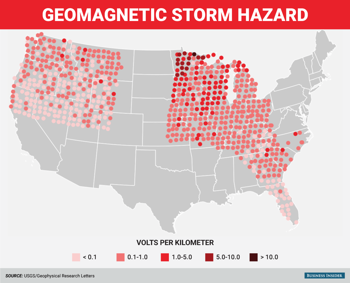
The map above shows where a geomagnetic storm's on-the-ground risk is the greatest in the US.
The darker the shade of red dot, the more electricity the ground will generate and conduct voltage into the power grid. Gray areas show where there is not yet enough data to map a geoelectric hazard.
While a volt or two — roughly equivalent to a small alkaline battery — spread over a kilometer may not seem like much, Love says the numbers are deceiving.
First, power transmission lines can extend for dozens or even hundreds of miles, so the voltage adds up. Second, the voltage fluctuates as wildly as the geomagnetic storm that's causing it in the ground.
"That's uncontrolled voltage in a system designed to control voltage. And it's not alternating current, it's more like a direct current," Love said. "That's something electrical transformers really don't like. They heat up and the coils inside can get fried."
When power transformers do go down, the damage is rarely isolated; disruptions can ripple across power grids and cause catastrophe.
For example, during the last major geomagnetic storm experienced by Earth in 1989, the entire Canadian province of Quebec went dark when a critical Canadian hydroelectric plant went down. Nearly 100 US electrical utilities connected by grid to the plant were disrupted as a result.
Meanwhile, GPS signals — which guide airplanes — were also lost for about 10 minutes, and auroras (caused by solar particles slamming into Earth's atmosphere) raced as far south as Cuba.
RELATED: See some of the most gorgeous solar eclipses
And all it took, says Love, was a geoelectric surge of about 2 volts per kilometer.
"We've found a lot of areas in the US that could exceed that voltage," Love said.
The map's 'missing' Northeast
To generate the US-wide geomagnetic storm hazard map, Love and his team merged two important sets of data.
One was several decades' worth of geomagnetic storm measurements, taken by monitoring stations all over the nation. The other was an ongoing "magnetotelluric" survey.
During a magnetotelluric survey, crews stick big electrodes into the soil, record the signal with recording machines, and move the stations over a large area for several weeks. The data they pick up reveals how rock layers, the water table, and other factors deep underground affect the conductivity of that region — and, in step, how much electricity a geomagnetic storm can induce there.
Love said large regions of the map are empty because there's currently no congressionally approved plan to map the US Northeast.
"Hello, that's where a lot of people live," Love said. "It's also where a lot of power grid infrastructures is located, and it's sitting on top of some complicated geology."
Love's concern for mapping the US Northeast is well-founded.
When hot weather drove up electrical demand in August 2003, and transmission lines sagged into overgrown trees in Ohio, 55 million people in the Northeast lost power for days. Sewage treatment plants went offline, railways suspended service, gas stations couldn't pump fuel, and mobile communications were disrupted.
"I hope that we can complete this survey for the rest of the country," Love said. "The map raises an obvious question: what about the other half?"
Love estimates it'd take a year and about $500,000 to hire crews to fill in New England and nearby regions on the new map.
"The hope is to help power utilities find out where their networks have weaknesses, how their systems might respond, and how they could alleviate problems," Love said. "If we don't do it, we don't know what the risk is in the Northeast ... Given the stakes, which are quite high, and the costs, which are quite low, it's worth it. $500,000 is about the price of a condo."
What's the deal with Minnesota?
NASA/SDO
One of the most at-risk areas on the new USGS map is northern Minnesota.
Love says this is due to "complex" geology in the region, plus the fact that planet's magnetic fields funnel high-energy solar particles toward Earth's poles.
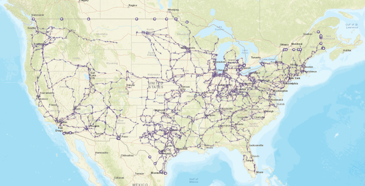
The hazardous areas map directly onto or close to several major Minnesota transmission lines (in purple):

NASA/SDO
Business Insider forwarded the new USGS study and map to the Minnesota Public Utilities Commission (MPUC), which regulates the state's electricity industry.
A MPUC representative declined to comment and instead directed us to contact the Midcontinent Independent System Operator, Inc. (MISO) — a nonprofit organization that oversees high-voltage power grid infrastructure and reliability across Minnesota, 14 other US states in the Midwest (in whole and in part), and parts of Canada. MISO didn't immediately provide comment.
We also contacted Allete, a company whose Minnesota Power (MP) utility serves more than 140,000 state residents and "some of the nation's largest industrial customers."
The company sent us comments from Kyle Rogers, a system performance engineer at MP, via an email from an Allete representative.
"In general, Minnesota Power has been aware for a long time that northern Minnesota is a hazardous location for geoelectric events and what we need to do to monitor and protect our system equipment and to design for potential disturbances," Rogers told Business Insider. "Also, the science behind GMD's [geomagnetic disturbances] and why we are at a heightened risk for has not ever changed."
Rogers added that the utility is signed up to receive alerts about solar storms from NOAA's Space Weather Prediction Center, then respond by keeping a close eye on the utility's transmission infrastructure for voltage swings and rising transformer temperatures.
He also said that while the new USGS research is "VERY useful for the entire electric industry," no utilities can yet act on it.
"This will change in the near-future, as everybody will be required to study a benchmark GMD event" for an upcoming standard being issued by the North American Electric Reliability Corporation. "At that point, the technical details in this research paper will provide important guidance when the industry works collaboratively on detailed planning models."
We forwarded Allete's response to Love, which included a 1991 industry-led study, and he said it was "very interesting."
"Insofar as they were aware of some geoelectric hazards associated with Northern Minnesota, our analysis puts all of this into a broader continental scale," Love said.
While the electric industry catches up to the threat posed by the sun, the best we can do is hope the next solar storm misses our planet — one barely missed us in July 2012 — and try to prepare for the worst.
NOW WATCH: The White House has a plan in case a solar storm wipes out our technology
See Also:
These sheets are one of the best purchases I've ever made — here's why
The sun will destroy Earth a lot sooner than you might think
SEE ALSO: 7 horrifying ways the Earth could die
